Updates
After extensive engagement and review, the Thames River Regulated Area Map Update, City of London has been posted for a final notification period (April 24-May 26, 2026). The draft map will be presented to the UTRCA's Board of Directors on May 26, 2026, for final approval. Thank you to everyone who provided feedback.
Any questions related to the map can be asked via the email box at the bottom of the page or mapupdates@thamesriver.ca.

How to search the regulated area map for your property
Follow the instructions below to access your property information from the draft maps.
- Begin typing your address in the search bar located on the top right beside the magnifying glass. Your address will appear as you type.
- Choose your property from the search results on the left.
- Pick "Show Map Layers" from the tool bar to view the legend. Click on the box beside a layer to turn map layers and features on and off.
- The overall red line is the draft Regulated Area and encompasses all the hazards and features in an area including allowances set out in O. Reg. 41/24.
What do the draft map layers mean?
The draft study area map shows the following layers or features:
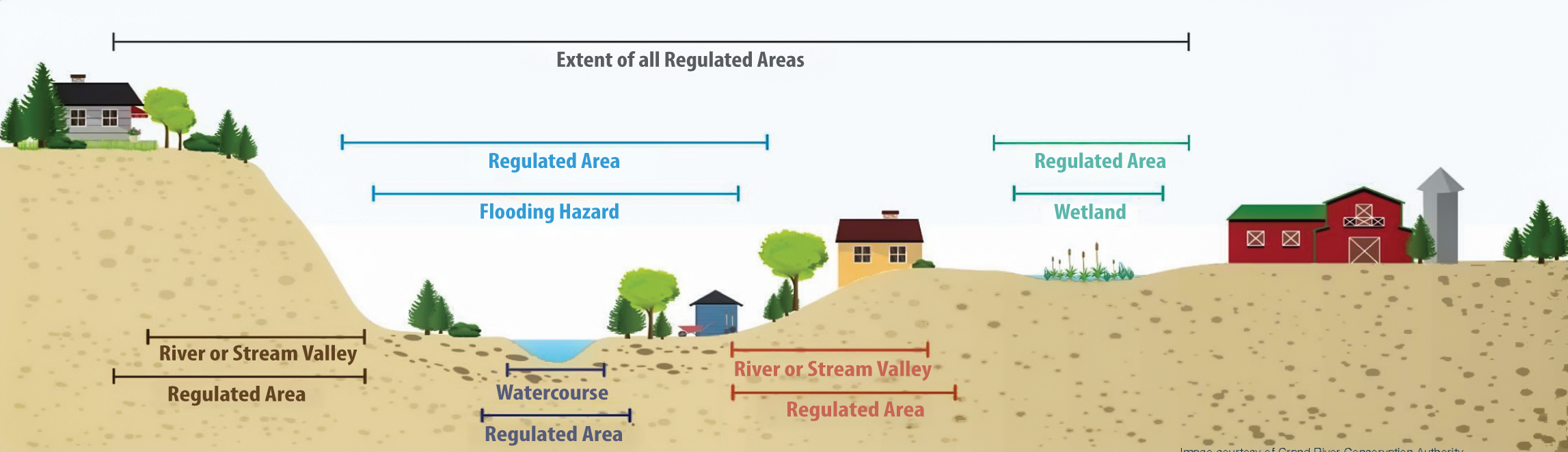
- Flooding Hazard – depicts the current flooding hazard for the 1937 Flood Event Standard (1:250-year return period flood).
- Flooding Hazard Updates – identifies the draft flooding hazard for the 1937 Flood Event Standard (1:250-year return period flood), based on new information or analysis (e.g., elevation data, field surveys, etc.).
- Flooding Hazard Limit - layer includes Flood Plain, High Ground - NO DRY ACCESS, and Other Buildings - Flood Hazard.
- Flood Plain - depicts low-lying lands adjacent to a river, stream or small inland lake that have been or may be subject to flooding during a flood event (1:250-year return period flood). The regulated area allowance is calculated from the outer limit of this line.
- High Ground - NO DRY ACCESS - depicts areas of high-ground (i.e., areas above the flood elevation) that would be surrounded by flood waters during the 1:250-year return period flood with no dry access to the property.
- Other Buildings - Flood Hazard - depicts buildings that intersect the floodplain and are included in the flood hazard limit and regulated area. More site-specific information is needed to determine flood hazard impacts on these structures.
- River or Stream Valley – depicts the current river or stream valley.
- River or Stream Valley Updates – identifies the draft river or stream valley based on new information or analysis (e.g., updated air photos, elevation data, etc.) to determine the projected stable top of slope.
- Wetlands – depicts the most current wetland layer.
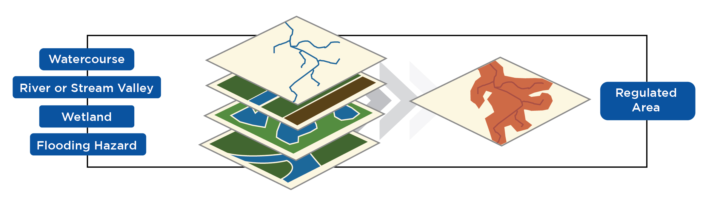
- Regulated Area – represents the greatest extent of the combined current hazards or features plus an allowance as required in Ontario Regulation 41/24.
- Draft Regulated Area – represents the greatest extent of the combined draft hazards or features plus the required allowance. There may be areas where the regulated area has expanded or reduced due to new information or analysis.
Note: Differences between the current and draft map layers reflect enhanced data quality, as the updated layers are based on more accurate and detailed information than before.
Overview
Project Background
Ontario’s municipalities and conservation authorities work to protect people and property from natural hazards, including flooding and erosion hazards, as well as wetlands and the area surrounding them. The Upper Thames River Conservation Authority (UTRCA) regulates development in or near natural hazards under the Conservation Authorities Act and Ontario Regulation 41/24: Prohibited Activities, Exemptions and Permits. Proposed development in regulated areas may require a permit from the UTRCA.
To illustrate the approximate location of the regulated area, the UTRCA develops maps that depict properties that may be affected by the regulation (O. Reg. 41/24). The regulated area maps are available online at maps.thamesriver.on.ca and in-person at the Watershed Conservation Centre.
Why update regulated area maps?
The UTRCA is undertaking a comprehensive review and update of its regulated area maps. Updating these maps is an important and ongoing process that enables the conservation authority and its municipal partners to use the most current information to identify hazards, assess risk, and guide land use decisions.
New data has greatly increased the accuracy of hazard identification. Advances in computer technology and software have also improved the UTRCA's ability to model and map hazard areas, especially flooding and erosion hazards. Changes and refinements to the approximate regulated area may occur and additional regulated areas may be identified, or previously identified areas may be modified or removed.
The UTRCA will notify or consult with member municipalities, the public and other interest-holders as part of the update process to ensure compliance with the regulation.
Videos
What is a Regulated Area Map?
Thames River Public Information Session
FAQ
O. Reg. 41/24 applies to lands within the following areas as outlined in the Conservation Authorities Act and further described in the Regulation:
- Hazardous lands,
- Wetlands,
- River or stream valleys,
- Areas adjacent or close to an inland lake and that may be affected by flooding, erosion, or dynamic beach hazards, and
- Other areas, including areas within 30 metres of a wetland.
Maps of regulated areas within the Upper Thames River watershed are available from UTRCA staff, at the Watershed Conservation Centre, and on UTRCA’s map website.
A permit is required from the UTRCA for the following activities within a regulated area:
- constructing, reconstructing, erecting, or placing a building or structure of any kind,
- any change to a building or structure that would have the effect of altering the use or potential use of the building or structure, increasing the size of the building or structure, or increasing the number of dwelling units in the building or structure,
- site grading,
- temporarily or permanently placing, dumping or removing any material originating on the site or elsewhere,
- straightening, changing, diverting, or interfering in any way with the existing channel of a river, creek, stream, or watercourse (all watercourses in the watershed),
- changing or interfering with a wetland in any way.
Hazardous land, as defined in O. Reg. 41/24, refer to land that could be unsafe for development because of naturally occurring processes associated with flooding, erosion, dynamic beaches, or unstable soil or bedrock.
Flooding occurs when a watercourse overflows its banks and spills onto adjacent low-lying land known as floodplains. These areas act as a natural extension of the watercourse during times of high flow to transport and store excess water. Development in a floodplain can alter the flow of water and cause or worsen flooding elsewhere, increasing the risk to life and property.
The flood event standard for each conservation authority is set by the Ministry of Natural Resources (MNR) and outlined in the schedules of O. Reg. 41/24. It is used to define the flooding hazard for regulatory purposes and illustration on regulated area maps. The regulatory flood event standard for the UTRCA watershed is the historical observed 1937 flood on the Thames River. This flood is estimated to be equivalent to a 1:250-year flood, or a flood with a 0.4 percent chance of occurring in any given year.
The UTRCA flooding hazard was reduced in 1989 when the UTRCA and member municipalities requested a flood event standard reduction from Hurricane Hazel to the 1937 Thames River Flood.
In O. Reg. 41/24, river or stream valleys are described as areas having depressional features associated with a river or stream, whether or not they contain a watercourse. Rivers and stream valleys are continually being shaped by erosion and flooding, resulting in a loss of land which can endanger life and property.
A watercourse, as described in O. Reg. 41/24, refers to a defined channel, having a bed and banks or sides, in which a flow of water regularly or continuously occurs. Altering a watercourse can impact its ability to move water, resulting in flooding and erosion downstream.
A wetland, as defined by O.Reg. 41/24, is land that:
- is seasonally or permanently covered by shallow water or has a water table close to or at its surface,
- directly contributes to the hydrological function of a watershed through connection with a surface watercourse,
- has hydric soils (i.e., saturated soils), the formation of which has been caused by the presence of abundant water, and
- has vegetation dominated by hydrophytic plants or water tolerant plants, the dominance of which has been favoured by the presence of abundant water.
Wetlands and the area surrounding them (30 metre buffer) are regulated due to their critical role in flood management as they store water and reduce downstream flows. Wetlands may also pose a risk to development due to the presence of a high-water table or unstable soils.
UTRCA staff determine the location and boundaries of individual hazards, such as flooding or river and stream valleys, through extensive data collection, statistical analysis, modelling, and various mapping techniques. Throughout this process, staff follow technical guidelines prepared by the Ministry of Natural Resources and Conservation Ontario. Using a Geographic Information System (GIS), the map layers showing each hazard are overlaid and an allowance is added to produce the regulated area. For more information, view the Regulated Area Map video.
Yes. Refinements to the extent of the regulated area may occur when new information (e.g., land use changes, bridge or culvert upgrades, new aerial photography, etc.) or analysis becomes available. As a result, additional regulated areas may be identified or previously identified areas may be modified or removed. The text descriptions in O. Reg. 41/24 override the mapping if there is a conflict.
If updates to the regulated area are significant, UTRCA will ensure that municipalities, interest-holders, and the public are notified of the proposed changes in accordance with requirements of the regulation.
The UTRCA provides publicly accessible Regulated Area Maps online and in-person at the Watershed Conservation Centre. UTRCA Regulations staff are also available to discuss property information by phone at 519-451-2800 or email at regulationsinquiry@thamesriver.ca.
If a property is regulated, individual homeowners, potential buyers, and professionals acting on behalf of a potential buyer (lawyer, real estate professional) may request a formal property inquiry from the UTRCA for a fee. The UTRCA will provide a written report with details regarding the regulated area on the property and site-specific mapping.
A property may be regulated for many reasons, and UTRCA staff can help you understand the basis for it. It is important for landowners to be aware of any natural hazards or features on or near their property and the associated risks. The regulated area may also have implications for construction or alterations on your property. It is best to contact the UTRCA before beginning any work so staff can determine if a conservation authority permit is required.
When a map is updated, the extent of the regulated area might change. UTRCA Regulated Area Maps will help you determine if your property is affected by the regulation. If your property is in a regulated area, you will need to contact the UTRCA before proceeding with any construction or alterations on your property. Staff will work with you to understand your proposed project and determine if a conservation authority permit is required.
Pre-consultation with the UTRCA is an important early step in any project. Contact the UTRCA prior to beginning any construction or alterations on your property to determine if a conservation authority permit is required.
Before contacting the UTRCA, please have the legal description of your property (e.g., municipal address, lot and concession, plan or block number) and/or a location map. The UTRCA can also provide written confirmation, and a detailed review of how your property is affected by the Conservation Authorities Act and Ontario Regulation 41/24 (fees may apply). If you have questions, call UTRCA staff at 519-451-2800.
Some homeowners have asked if the regulated area might affect property insurance or home values. The UTRCA is unable to offer advice on these issues and encourages landowners to contact their insurance provider, a qualified real estate professional, or the Municipal Property Assessment Corporation for guidance. Information can also be found at the Insurance Bureau of Canada.


